Saturday 14 November 2009

New Zealand 2009 Week 4 (last 11 days)


Even though the nights and mornings were quite cool, I was quite pleased that I no longer had beanie-hair – a weird flattened style with a pointed top! Once again we weaved our way up then down Takaka Hill. The GPS registered 805m, but I read somewhere that the actual mountains were 900-and something high.


We heard on the news that NZ had just experienced its coldest October in 64 years – Great! We took an even windier and narrower, but thankfully less busy diversion north through the pretty seaside town of Kaiteriteri - Darryl said it was so windy he could look for oncoming vehicles in his rear vision mirror! Several of the corners had convex mirrors on them. We made it safely to Marahau, the southernmost settlement before the Abel Tasman National Park. It was a lovely morning, and Darryl set out on his walk along the Abel Tasman Track.
 I had morning tea, pottered around the van (if you can really potter in 3m-squared), tidying up (and finding my misplaced watch – exactly where it should have been, with the other valuables) – then set out on my walk. I only went as far as the first 'walk'  - Tinline Bay. It was supposed to be ½ an hour, but getting there took me 45 minutes, as I diverted off the beaches and lookouts, and took numerous photos. A lovely leisurely stroll! The return walk was ½ an hour, as the sky as darkening, and I wanted to remain dry.
Back at the van I had lunch, had a nap and read some of my novel before Darryl returned. He had walked the 12km to Anchorage Bay, then return (I might note that he tore a muscle in his leg the day we went to Fox Glacier, and has been limping since). He felt that he wanted to give his leg a good work-out. 
We made it to Kina Beach Reserve to camp for the night. A short beach walk revealed tiny starfish and chitons under the rocks, and further out Darryl found more mussels, but did not collect any.

Another magical day dawned, and we wandered around Richmond until their library opened, then drove along the shoreline to Nelson. I know that being such a beautiful day affects your attitude to places, but Nelson seemed just lovely. 


We walked to the geographic centre of NZ on top of a hill in a reserve. The views from the top were wonderful, of Golden Bay, Mt Arthur, and the city. I was thrilled when 2 Tui landed nearby on a flax plant , but too far away for food photo, . They have a really beautiful musical, chiming call.

Despite really liking Nelson, we decided to continue on to Pelorus Bridge, and camped at a DOC site which had powered sites, kitchen and clothes washing facilities.After setting up we did a short walk to a swing-bridge across the Rai River. On the other side we were greeted by a dog who came out of the forest. She looked very skinny and lost, and accompanied us as we did part of the Circle Walk. Back at the swing bridge she was too scared to cross, so I encouraged her, then guided her to the Cafe/DOC building. Initially they were concerned that she was my dog and that I was bringing her illegally into the Reserve, but once dissuaded of that notion, they rang a local farmer who came and collected her (thankfully, as once tied up she started barking).

We were the only ones at the powered sites section, apart from the rats living in the ceiling of the kitchen. This was Guy Fawkes (or Cracker-night). Since it has been banned in Australia for many years now I was very tempted to buy some fireworks, but realising that we would be overnight in a National Park, had decided against it.

We shifted the van to a parking spot near the Cafe and started off on the Elvy Waterfalls track. This led to 2 rather disappointing waterfalls, but the walk along river was lovely, overlooking the most amazing blue water. 


We drove to Havelock, and stopped briefly to admire their marina, which is so sheltered it appeared to be surrounded by hills. Further on, a short walk to a lookout gave spectacular views both sides, of Havelock and Mahau Sound.
We turned off at Linkwater and took the winding road to the other side, stopping for lunch at Ohingaroa Bay, before driving further along to Te Mahia, and to see the sparkling azure waters of Kenepuru Sound. We had to return to Linkwater to get back on the highway, and then turned into Anakiwa, to the start of the Queen Charlotte Track. Walking along this track for the hour to Davis Bay gave more stunning views of that wonderful water, many treeferns, and even a Weka (which seems to be similar to a Kiwi in habit and mannerisms, but has a short beak, and does not seem to be nocturnal).
Back on the main highway (Queen Charlotte Drive), and on the opposite side of Queen Charlotte Sound, we found a campsite at Aussie Bay, and Darryl went off to collect more mussels – unfortunately the ones here were diseased.

We drove into Picton, where the ferry arrives from North Island. The
lookout gave a clear view of the town, but we went down to find out the ferry times, and then discovered the lookout from the other side was closed. We had to be content with checking out the historic ship Echo, which is now dry-docked, and a restaurant up for sale.
A very winding and narrow road (also becoming gravel!) led around the coast to Robin Hood Bay, where we stopped for a cuppa, and a look at an 1848 'mud and stud' whaler's cottage. Further south was Whites Bay, with an 1866 inter-island telegraph station, a lifesavers club, and some walks. This location was very popular. We walked part of the Black Jack Track to a lookout, and then the Pukatea Bushwalk, through regenerating bush. 

We cooled our heels at Rarangi, fascinated by the stones on the beach, then walk over to Monkey Bay, a tiny bay accessed by stone steps. 
Dusk on Rarangi Beach was almost magical, with mountain and cliffs in the background. Unfortunately, then hundreds of mossies almost made off with the van. We did not venture out, but somehow a dozen or so still got in! Later in the night I as entertained by fireworks coming from the neighbouring Monkey Bay.

 Sunday proved to start out as a rather disappointing day. The beautiful skies had disappeared behind clouds. We thought we would check out the Wairu Lagoons at Blenheim. The start of this walk is through a sewerage treatment plant....and that just put me off completely. Next was Lake Grassmere – which might have been interesting if we could get anywhere near it – was fenced off and distant. 
This was on the way to Marfells Beach, which, to us, seemed desolate and uninviting, topped off by Cape Campbell. This site apparently had a historic lighthouse, but it could not be seen or accessed by anything less than a full days walk. We then thought we would make for Sawcut Gorge, a 12km gravel road off the highway. This was a 3 hour walk with multiple river crossings, and although I started, I realised that after the first rock scramble that my back was not up to it (also not helped by the freezing rain starting to fall). Darryl did not want to do this walk without me, so we headed back to the highway. 
Down this stretch of coast we were looking for Ohau, where there was supposed to be a waterfall, and seal colony. It was not on any of my maps, but we could not miss all the seals draped on the rocks, as Ohau lookout and seal colony came into view. This was by far the biggest and closest seal colony we had seen. While we were there a pup as born in front of us, although we missed the actual moment. It seemed unusual to us that the mother was still suckling an older pup. Gulls came in and cleaned up the afterbirth, but did not touch the newborn pup, which seemed a little listless.

While here, the clouds lifted, and blue skies lit up the water beautifully. We then drove back a short way to Ohau Waterfall, a short 10 minute walk up the hill, and were delighted to find 3 pups 'parked' there by their mothers, while they went out fishing. Two of the pups were frolicking in the pool below the waterfall. The whole ocean-front from here to Kaikoura was very interesting, with lots of rocks. Kaikoura Peninsular was quite stunning, with wonderful creamy limestone, angled sharply upwards, with a backdrop of snow-covered mountains. The seals here were less in number, but it was possible to walk down among them. In fact, it was quite interesting watching the various groups of people viewing the seals. We decided to stop in a Holiday Park in Kaikoura, and have fish and chips for dinner, as this place was renown for its seafood. (We enjoyed our meal in Hokitika more, though).
Morning revealed dark skies and heavy rain. We packed up, and headed off, knowing that not much would happen. The map showed Parititahi and Ramari Tunnels, which turned out to be road tunnels, along the rugged coastline, which we passed through, but the only thing we could see which resembled 'Rock Art' (as featured on the map) was graffiti in the tunnel! We passed Mt Parnassus (of interest to us as there is also one near Rockhampton), but were unable to see it due to the clouds and rain. 
At Cheviot, we diverted to Gore Bay featuring Cathedral Cliffs, which did not seem very impressive in the gloom. We ended up at Amberley Beach, and although it was cold, wet and dreary, the council holiday park was impressively cheap, so we chilled out and had a quiet afternoon.
Although the morning was dry, it was quite cold as we drove, bypassing Christchurch city centre, through a long tunnel to the quaint Lyttleton. This town is amazing considering it is also an industrial harbour. This harbour, and the Arkaroa Harbour further around on Banks Peninsula are the craters of extinct volcanoes. 
The drive around to Governor's Bay was past quaint little houses with plenty of blooming gardens.
A tourist drive took us on the Summit Road almost the crest of the rim of the volcano, and up to 650m, with sweeping views down both sides to the bays, and interesting rock formations. This drive ended up at Akaroa, an early French Settlement. The whole Peninsula was bought by Frenchmen in 1838, from the Maoris, but by the time the settlers returned, the Treaty of Waitangi had been signed between the Maori nations and the British, giving the British sovereignty. The French sold their assets but many settlers chose to remain at Akaroa, and many places and names reflect this. We walked along the quaint waterfront, enjoying the huge War Memorial (all those here have memorials to 'The South African War', which is more normally called the Boer War in Australia), Gaiety Hall, Coronation Library, defensive cannon, and landmark lighthouse. Back in Christchurch we ended up at a holiday park right next to the Racecourse (perhaps not the best idea given that it was the biggest race-day of the year!)

We woke to the forecast freezing rain, so it seemed best to have a museum day. Christchurch has plenty of interesting old buildings, mall areas especially around the central cathedral, historic trams, statues and sculptures. This is all complimented by the gorgeous botanic gardens, with the Avon River running through, and the whole effect is of a very English city (or was it just the bitterly cold wind and rain......).

We wandered around the city centre, popping into various museum displays, and the Christchurch City Library, before exploring the museum, and, once the sun came out, the lovely gardens with their gargantuan trees, flower beds, and hothouses. 


While crossing the bridge from the carpark to the gardens, we saw a beautiful trout just sitting in the stream, and the water was so clear you could see the ducks upturning and picking the weed from the bottom.

A beautiful sunny day greeted us, so we thought it was an ideal one to check out the Christchurch Gondola. I managed to get us heading the wrong direction on the motorway (heading west instead of east), but due to congestion of the east-heading traffic, Darryl wanted to avoid it, so we took the 'scenic' route, through the university, and right through the centre of the city (which I had been trying to avoid).


We arrived at the gondola just as it opened and enjoyed the 10 minute, 945m lift to the top (500m above sea level). There we were able to enjoy slightly hazy views across the city, to the snow-topped mountains of the Southern Alps, and down the other side to Littleton, and the Banks Peninsula. We were able to walk along the rim of the extinct volcano, and, trying to find the 'Summit' we found a blocked off track, which turned out to be the 'lost mountain-goat track' – I ended up crawling up on my hands and knees in a couple of places! 
I was really hoping our path wouldn't be blocked, as there was no way I was going back down the slippery, muddy slope. Eventually, though, we reached the top of the rim, but were not able to go to the actual summit as it was gated off. We found our way back to the Summit Road and walked back to the Gondola Centre. Our ticket included a 'ride through time' which was a short, but quite interesting automated ride showing 12 million years of the history of NZ.

As it was such a lovely day, we once again, walked around the centre of the city, but this time following the paths on a couple of self-guided walks. We saw punting on the Avon, Victoria Square, which has statues of Queen Victoria, and Captain Cook, among other historic buildings and features. 


A visit to the Christchurch Art gallery was 'enlightening', and even I was amazed that they had even bothered to hang most of the pieces, although there were two excellent masters hanging. We met up with James, and his wife Elizabeth, at a Bistro Bar for dinner. They are a really lovely and generous couple, and we had a very enjoyable evening.
Our final day in NZ was spent at the Air Force Museum at Wigram. There was a cold front which hit with 90km an hour gusts and rain, so it was good to be inside, especially as the temperature dropped 10 degrees. There were plenty
of planes, including a tiger moth, and an Australian plane. The museum was nicely set up with some really interesting displays. The remainder of the day was spent cleaning up the motorhome, for its return, and packing our bags at the motel near the airport. The flight to Sydney left at 6am the this morning, and we arrived safely back home in Rockhampton just before midday.

Thursday 5 November 2009

New Zealand Week 3

We knew it was cold during the night, and pretty cold in the morning...we even slept in! Eventually we got out of bed (none of the people in the other vans stirred for ages after us), and went over to the DOC (Dept of Conservation) Centre where we were informed that it got down to zero degrees, and that the following night they were expecting snow.
The Centre had some excellent displays and information, and were even selling possum pelts for $45 each (the possums were introduced from Australia in the 1800's and are a terrible pest here). Darryl went off on the Bridal Veils Falls walk, but we were unable to go to Devil's Punchbowl Falls as they were closed.


Further toward the east was Cave Stream Scenic Reserve, where there were fantastic limestone formations with fossils, and weird rocks 'gathered' with the largest ones on the tops of the smooth hills. Apparently, the limestone platforms had been pushed up by the tougher rock of rising mountains. There was a cave which the stream ran through, and you could walk through if you were prepared to go waist deep through the water. Although Darryl had been contemplating walking through (as it was a tunnel with an entrance and exit), he dipped his fingers in the icy stream and decided against it. 
Further on was Castle Hill Village, and the rock formations certainly looked like ruined castles. This whole area is just heaven for someone like me who loves huge rocks and mountains. Further down the road was one of the funniest events - a herd of cattle were grouped around in a circle. Initially it looked like a couple of young bulls 'shaping up' and the others gathering round to egg them on, but then Darryl realised that a plastic shopping bag had blown into the paddock, and they were circled around that. I am still laughing!
We were still having trouble with the deep-cycle battery, so phoned the Camper place and found that the only place we could get a replacement was at their depot in Christchurch, so headed there. The problem was not with the battery itself, but turned out to be a blown fuse. They replaced it and we were soon on our way. We had been planning to camp at Mt Thomas Forest, so drove out through Rangiora. At the turnoff to the official site, we were faced with a dusty gravel road, and so opted instead to pull up beside the river. It was lovely and warm in the afternoon sun.
Big black storm clouds rolled over, and it rained during the night (though it didn't wash the dirt off the van). At one point during the night I woke and felt quite cold, so pulled on my beanie and went back to sleep. Imagine our surprise, in the morning, to pull back the curtains and find that it had snowed! It was melting down, but the windscreen was a third covered, and the paddocks and mountains were all freshly covered. 
We drove back into Rangiora, and waited for the local library to open. A wonderful librarian gave me 20 minutes of her undivided attention looking for the gravesites of William Jordan and his wife Elizabeth (nee Parker – on my Anderson side). Their database had all the local burials, even for the town of Oxford, where William was said to be a farmer when his wife died in 1870. They weren't there, or even on the Christchurch listings, which she also looked up for me. She also checked local histories and found mention of a Mr Jordan, who was a printer in Oxford in 1925, and an earlier Mr Jordan who was a farmer in the 1870's, but no further information.
I must say that I really enjoy watching the sheep in the paddocks with their lambs. Many have twins or triplets, and I have seen several with 4.
We continued our journey, north, and arrived at Hell's Gate Corner where a jet boat was thrilling passengers through a narrow gorge. Just up the road was Hanmer Springs. The town has thermal springs, but as it was so commercial we decided on some walking instead. Unfortunately our walk to a waterfall was misdirected by me misunderstanding some road closures, due to logging, and their map, we walked for over an hour in the wrong direction.
West along the highway we were looking for the Sylvia Flat Hot Springs, but they were so un-commercial that there wasn't even a sign, and so we didn't find it. We pulled in at the Deer Flat camping area.


This was beside the Lewis River, and surrounded by beech forest. It had obviously snowed here, too, the previous night, as there were remaining patches of it, and someone had built a snowman....which, worryingly, was still standing at 5pm.
In the morning we drove a few km up the road, and pulled up at St James Walk carpark. The first surprise to us was a picturesque little tarn which had water vapour rising and beautiful reflections of the snow-topped mountains. We did the Alpine Nature walk and found out that NZ has 5 types of beech trees, and then started up the road on the Lewis Pass Lookout track. We were supposed to make our entry about 400m up the road, but an earlier track sign diverted us up through mossy beech forest. We were sinking into the deep spongy mosses underfoot, and unfortunately wet our shoes on a few of the many stream crossings. The views from the top were excellent, of Cannibal Gorge, several mountains, and the Maruia River. It was supposed to be a loop, so we took the track on the left coming down, only to find that it was probable the correct ascent, but it was nowhere near as nice as the path (not really a track) that we were on, so I was pleased (despite the soggy shoes and socks) of the mistake.
Our next port of call as Maruia Hot Springs. This was more expensive to enter than Hanmer Springs, but was really natural and beautiful. It as done as a Japanese resort, and the rock pools varied in temperature from quite cool, to really quite hot. We spent nearly 2 hours languishing in the medium temperature pool, occasionally venturing for a few minutes into the hot pool. The water was not chemically treated, and had green and black mosses (which the signs said are supposed to be good for your skin) throughout. In the sulphurous water my skin felt soft, and later it felt good, but initially when getting out the oils seemed to be stripped away and it felt a bit dry. After this we both felt really tired (despite a long sleep the previous night), and napped for an hour and a half before driving on.


We were hoping to do a waterfall walk, but it was closed due to 1080 baiting, and when we arrived at our night camp at Marble Hill, we found DOC constantly filling the bins on 3 helicopters to spread the bait (they continued until darl at 8.30pm). The walks here were also closed, and we spoke to a Ranger who explained that the previous good season meant a huge amount of beech seed produced, and the mouse and rat populations had exploded.  When they bait, they also get the secondary bonus of killing the stoats, which feed on the poisoned rodents. This area also seemed to have lots of rabbits, so hopefully it will help control them. An interesting feature was an 80' wall built in last century across the Alpine Fault line to monitor movement – I am pleased to say that it is still perfectly straight. We had some visitors during the night as rodents got into the food cupboard, so Darryl put all the rice, fruit and noodles into the microwave and the potatoes into saucepans with the lids on.
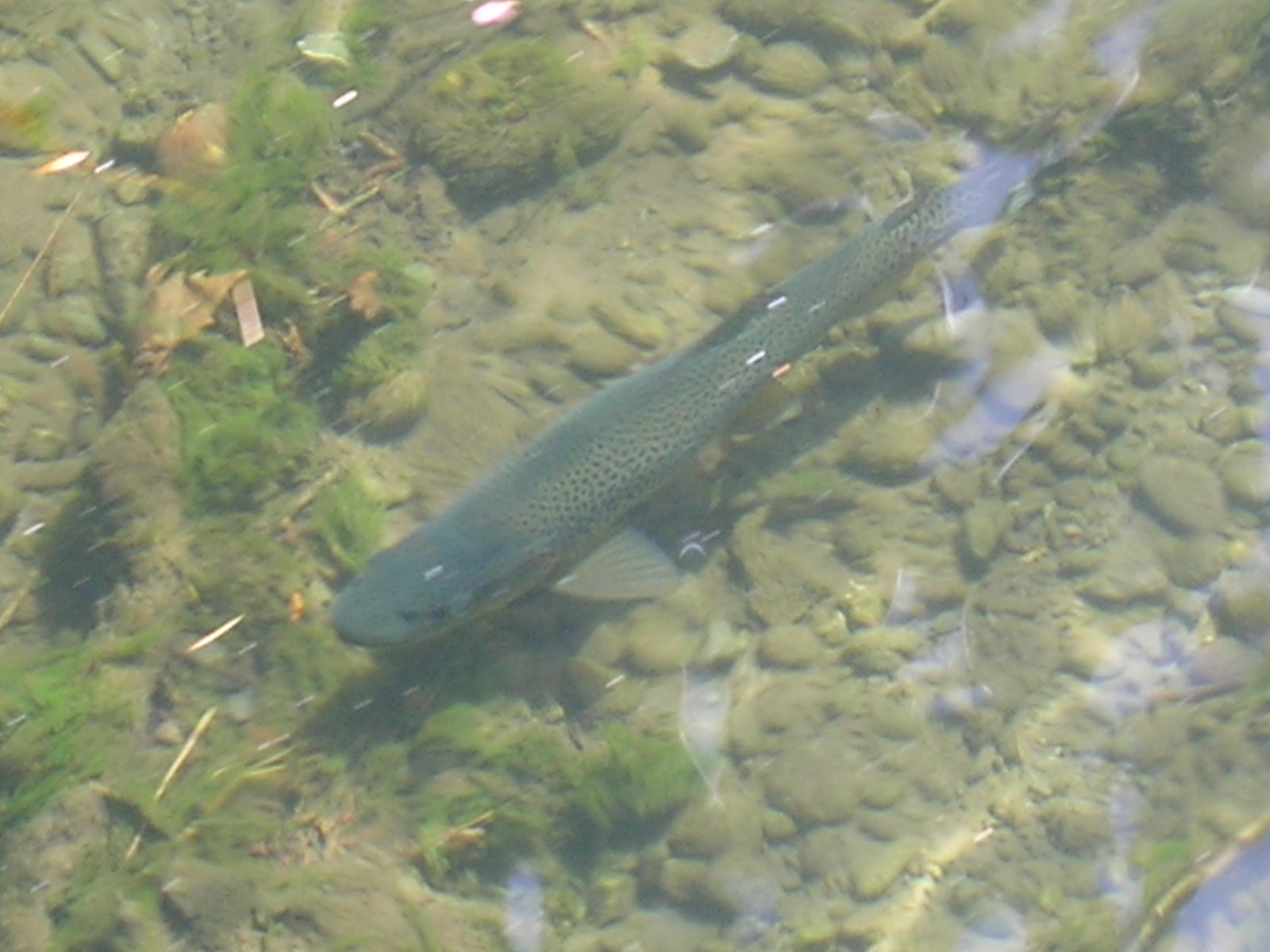
From the camp was a short walk to 'The Sluice Box' a narrow slot gouged into a marble outcrop by the Mariua River. From the bridge we could see several trout in the deep clear water flowing through it. We drove west towards Reefton – a gold mining area – and stopped to walk in to Bolithos Mine (we think it was a coal mine). Greymouth has very interesting steep and sloping rock layers either side of the Grey River bridge. We had lunch between the beach and the airport, after an abortive attempt to find a 'nice' park. The route north towards Westport was very scenic, with winding roads clinging to the coastline, and eroded monoliths in the ocean beside. 
Motukiekie Rocks was fascinating, and just north of them we saw people collecting NZ Green-lipped mussels, so, of course, Darryl braved the cold ocean to collect enough for us for dinner (we had them in a white wine and butter sauce with Capsicum Rice – Yum!!!!) 


Our next WOW moment was Pancake Rocks at Punakaiki. These are layered rocks at the ocean edge, and reminded me of photos of the temples at Ankhor What. The walk here was really beautiful, starting in rainforest, opening up into flax areas, and we saw lots of the Nikau palm (the southernmost naturally growing palm in the world) with its strange upward pointing fronds. There were caverns, blowholes, and bridges.
 Punakaiki Cavern was a few hundred metres back along the road, and although it had started drizzling we went to investigate. It was quite interesting, and you could venture quite deep inside.

Up the road was the Truman Track, said to be one of the nicest short walks. This walk passed though virgin rainforest (and it was still raining a bit), down to a stunning coastline of layered sandstone and mudstone. There were shell fossils in the stone, and layers of erosion that looked like large froth bubbles, caves and overhangs, and even a waterfall. Further north, we took the road to Cape Foulwind. Named by Captain Cook, due to several days of foul weather he had experienced here, it had been previously visited by the Dutchman Able Tasman.
The walkway around the cliff led to a seal colony. Plenty of them were draped on the sheltered rocks, and some were playing out in the water. Apparently it is weaning time for the pups, but we were lucky to catch one suckling. There was supposed to be a replica Astrolabe along the walk, but the pedestal was bare...

We went into Westport for a look before taking the highway east again. Fern Arch was a half-bridge (single lane with lights) around a rocky bend, and then at Hawk's Crag the road went under a half-tunnel. White Cliffs was dominated by high limestone cliffs, and we stopped briefly at Lyell, an ex-gold mining town site. Darryl went for the historical walk, but we decided not to camp there due to the numbers of mice and sandflies. There was not much to see on the drive to Kawatiri, where we stopped for the night. This was a historical  railway siding, with a bit of the old bridge, a railway walk, and some interpretive signs. The sandflies here were in flocks and ferocious.

In the morning Darryl did the historical train walk up to, and through, the tunnel. It was then on the road again, heading north to Motueka, hopefully away from the rain. Although a scenic farming valley, the only unusual feature were some very strange funnel-shaped clouds. At Motueka we used the local library internet, as my phone connection was not working.
From here we had the Takaka Hill drive, up some very steep winding road. There was a walk through a private property which passed numerous tomos (sinkholes) in the marble limestone, and also, really strangely a little hut which held a mummified cow! 

Just north of Takaka is Te Waikoropupu Springs (purportedly the World's largest freshest spring). The water was crystal clear, you could easily see metres to the bottom, and there was 8 holes gushing up into a small lake. We had passed some motorhomes stopped on the southern bank of the river the springs formed, and we returned to set up camp for the night – at last no sandflies, no rain, and warm afternoon sun – lovely! In the evening another couple, from Melbourne, Russell and Vallie, turned up, and we spent the evening chatting with them and sharing maps and 'must-do's'.
I have noticed a couple of things, the South Island is very Scottish, lots of Scottish place, street and sur-names, but also in Rangiora the schoolgirls were wearing ankle length plaid skirts. Also, what I had thought was wildflowers, is a terrible weed, the prickly yellow-flowering gorse. Apparently, as little as 50 years ago bags of the seed were being sold  for  'quick-growing' hedges, now it is a pest.
We had quite an early start, and found the 'Devil's Boots', a sandstone outcrop, but could not locate the Aorere Gold Fields. 
Then it was off to the northernmost tip of the South Island, and we tiptoed across sheep-dropping strewn paths to Wharariki Beach, with its sandstone rock island, Cape Farewell where there was an ocean-carved arch (and more in te process of being formed) – this is the most northern point) – and 3 seal mothers frolicking, or feeding, in the ocean while their respective pups slept on the rocks, and to Farewell Spit lookout which gave lovely views of Golden Bay, with thousands of black swans swimming near the shores. Heading south again, we stopped at Onekaka wharf – not much left, only a few rotting pylons -  and the remains of the Onekaka Iron Works – only a few disintegrating buildings, and rusty bits of steel.
From here we went around to the southern part of Golden Bay to a pretty bay called Wainui, and walked in to Wainui Falls. This walk was characterised by the tallest treeferns we have ever seen, and a fragile one-person suspension bridge, but it was really worth it, to see the beautiful powerful waterfall gushing down through the massive waterworn sandstone boulders. We tried to camp at the harbour, near a rock tunnel, and stopped and watched some fishing boats being loaded with nets and anchors, but after chatting to some locals we moved on and returned to the same spot as the previous night, beside the Waikoropupu River (beside the local white-baiters). The weather is perfect – warm with a cool breeze, and still no sandflies.